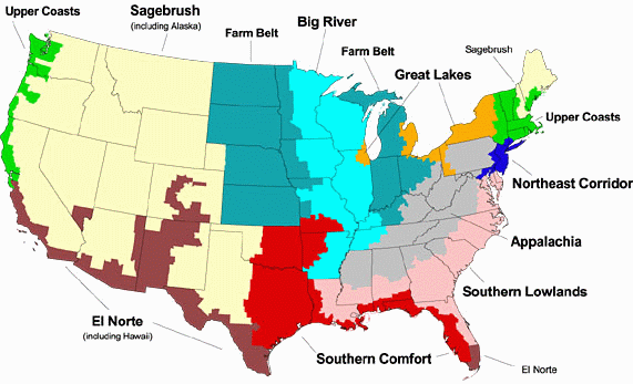
New Political Map of the US: Implication for Elections and Iraq
Robert David Sullivan, writing in The Commonwealth, has proposed a new political map of the US based on long-term county-specific voting patterns (there are about 3000 counties in the US), and divides the country into 10 regions on that basis. (Note that the map at his site is clickable and that version offers more details about the regions).
Sullivan argues that of the ten demographic regions he identifies, 5 voted Republican and 5 Democrat in the last election, although only three have always voted Republican for 35 years. Clinton won 6 in each election, but Bush only won 5 (the right configuration of the right 5). Bush’s challenger is unlikely to be able to win with 5, and needs six.
Any Democratic ticket will need to make inroads into at least one Republican-leaning area, as well as keeping what Gore got in 2000. Believe it or not, I think such a ticket has a shot in Appalachia. Not in the Southern Lowlands or Southern Comfort, of course, which would be laughable. But Appalachia is a different kettle of fish. My family is from there on my mother’s side, and I can tell you that foreign adventurism and spending $166 billion on Iraq when there was no real threat (from a man in a spider hole) could be very unpopular there if the pitch is made right. Appalachians are patriotic and do not like Northeasterners putting on airs, so some Democratic candidates would fare better than others. But if one of them could connect with people about how they are being screwed over by Bush’s giveaways to the New York financiers and by his expensive foreign adventures (there are lots of schools in Appalachia that need paint), then the Dems might just be able to get this region. Hint: Bringing someone on board the Democratic campaign team who has won elections in Appalachia would help.


 © 2025 All Rights Reserved